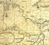


Strait of Hormuz

The Strait of Hormuz (red arrow) relative to the Arabian Peninsula and Persian Gulf.
Blue arrows illustrate the strait's Traffic Separation Scheme.

Satellite image

Map of Strait of Hormuz with maritime political boundaries (2004)

The strategic strait of Hormuz in Persian Gulf
Writer: Rozbeh Parsapoor
Translate by: Yasaman Gholami
One of the most important international straits of the world is strategic Strait of Hormuz, which is one of the most vital traffic straits of the world. Iran is the controller of this strait. Therefore, it enhances the military force of the country. Iran is a pacifistic country, although, the western countries and their allies in the Middle East did a lot of inhuman things but Iran never used the option of closing the Hormuz strait. There are more than 100 straits between oceans and canals in the entire world which their width is below 40 kilometers (25 miles). If somebody rates them based on the number of ships, economic excellence, geographic vulnerability and military usefulness, the top five straits which are the gates of Middle East and north of Africa are: Hormuz strait in the south of Iran, strait of Gibraltar, Bosporus strait, Dardanelles in Turkey and Babb-el-Mandeb strait. Hormuz strait is a curved beam sea that separates the Iranian plateau from the Arabian Peninsula, and it connects the Persian Gulf to the sea of Oman and Indian Ocean. This strait is a trough from the third period of geological, which cuts along of the mountains of south of Iran to the Musandam peninsula. There is no special criterion for identify the length of Hormuz strait but maybe the maritime boundary between Iran and Oman be the best criterion for this. The length of this boundary line is 202.1 kilometers (124.8 nautical miles). The longest distance of Strait of Hormuz is 84 kilometers (from the shore of Bandar-Abbas in the north to the northeast place of shore of Musandam in the south), and the shortest distance is estimated 33.6 kilometers (between Iranian island, Lark in the north and the Oman island, Alsalame, or in other words, greater Quwian island in the south).
The sea bed in the Hormuz strait is a high steep from the north to the south. In recent decades, because of using the heavy oil tankers, these tankers just are able to transport in the deepest part of this strait in the Musandam shores but in the past, the way of oil tanker ships in the Hormuz strait was between lesser Quwain and rocky shores of the Musandam Island until 1979. In this year, the Oman government announced to the international maritime consulting organization (IMCO), that this government cannot guarantee the safety of the ships which are passing the distance between the lesser Quwain Island and the rocks of Musandam Island anymore. They demanded to recognition shipping route from the north of Alsalame Island to the Iran maritime borders, then they considered two parallel shipping routes for the oil tankers in the north and south, between Quwain Island (greater and lesser) and the border between Iran and Oman.
Origins of the name of Hormuz strait
Because of dominance of Iranians generally Middle East and the west of Asia in the past, this strait (Hormuz), has a Persian name, as well as the Persian Gulf. In fact, all the countries that nowadays are existed in this region are the result of colonialism of the England government. There are three ways to investigate the origins of the name of Hormuz strait. First of all, the ancient people made the name Hormuz, from the name of Persian God, Ahura-Mazda. In Iranian ancient religious, Ahura-Mazda is also known as Ohrmazda, Aramazd, Hourmazd or Ahuramazda. In the second possibility, in the Sassanid Empire, the name of kings who made a business center from the Persian Gulf was Hormuz, and because of this reason, they named this strait after their names. And the third possibility is maybe they named this strategic strait because of the city near it was named Hormuz. The remains of that ancient city still exist in the Hormuzgan province. However, most of the experts believe that this nomination is because of the vicinity of this strait to the Hormuz city. Nevertheless, Hormuz is also the name of five Sassanid kings (224-652 A.C) which are as follows:
King Hormuz I (273- 274 A.C) was son of King Shapour I. King Hormuz II (303-310 A.C) was the 8th Sassanid king and also known as Narseh. King Hormuz III (457-459 A.C) was the son of Yazdgerd II, and he was the 17th king of Sassanid Empire. The King Hormuz IV (579-590 A.C) was the 24th king of Sassanid empire and the King Hormuz V (632 A.C) was the 31yh king of this Empire.
Geo-strategic of Strait of Hormuz
The length of this strait is about 100 nautical miles (182 kilometers) and in the shorten part its width is about 21 nautical miles. This strain is between the Iranian island, Lark and the Oman Island, greater Quwain. The Hormuz strain located between the Iran (in north) and Musandam peninsula of Oman (in south). Both governments of Iran and Oman clam that they got 12 nautical miles of the ownership the Hormuz strait.
The land conflicts are because of the short width in the shorten part of the strait which is about 21 miles. In the beaches of Iran, the depth of Hormuz strait is lesser in the beach sides of Iran. Iran has six strategic Island (Hormuz, Lark, Queshm, Hengam, lesser Tunb, greater Tunb and Abu Musa.) are located in the entrance of Oman sea to the Persian Gulf. They are shaped like an arc, and they are known as Iranian defensive arc against the possible aggressions. The Hormuz island which is located in Hormuz strait is a geopolitical and geo-economical place, which in the Achaemenian empire era (330-550 BCE) was a site navigation (Eghtedari, 1344- 45) and in the time of occupation of south of Iran by Portugal, They used this island to connect the Persian Gulf to the Indian Ocean. In the 18 and 19 century, the Hormuz island was the cross way to transport the spice from the Calicut port of India to the Europe. (The geography and national strategies of Iran- Dr. Masoome Taheri Moosavi, page 148).
Iran has the dominance of Persian Gulf, and this country has the most borders with this sea and also Iran has thousand years of maritime history, so Iran always wants safety and security in this high strategic region. However, the great source of energy in the Persian Gulf is the supply center for Europe and American countries, and if this source be cut, they would be defeated. So the newly established countries which are opportunistic and warrior, want to make this region insecure and have the domination of the countries of the south of Persian Gulf, in order to find a place to this Iranian region. Patrick Cluase, the researcher of middle East issues in the near east Institute of Washington, pointed to this issue in a press conference: The Hormuz strait is a cross way for transporting about 40 percent of the oil of the world and if this strait be closed for a long time, the international economy would be failed.( Fars News, the news number 8503190083). All the economic and military experts of Persian Gulf in the world are agreed that the Hormuz strait has geographical importance for the entire world, because it is the transport bottleneck of the oil of the world. The Persian Gulf countries, i.e. Iran, Saudi Arabia, Iraq, Kuwait, Qatar and United Arabic Emirates exported 18 million and 200 thousand barrels of oil per day, in 2006, and 17 million barrels of this were transported from Hormuz strait to the international markets. This is the fifth of world oil consumption. These countries have 728 billion oil barrels' storage, and they have 55 percent of the oil of the world and also more than 5.3 billion cubic feet of natural gas will be transferred by the gas tankers from this strait to the Asia, Europe and North America.
Hormuz strait is important for Iran and Iran has a border with Oman in this strait, so Iranian government called Oman as a friend country in all the times. For example, we can mention to the sending military forces and equipments to the Dhofar region in Oman in 1975.
Dhofar rebellious was supported by communist ideas of China and Iraq, after reconciliation between Iran and China in 1973 and also Iran and Iraq in 1975, this rebellious was ended by the cooperation of Iran’s government (Mojtahedzade-1380-26).
In the beginning of the 10th century, the King Ismail I formed the central government in Iran, that was a start to end the Portuguese colonialism in the Persian Gulf. The great King Abbas in a partnership with England's navy could defeat the Portuguese at the Persian Gulf in the 1030 A.C and send them out of the Hormuz island in 1031 A.C. thus, the Hormuz Island and strait and the whole Persian Gulf return to its owner after a period of European occupation. Iran is the greatest and most powerful country in the Persian Gulf. It has the largest geographical range protective stance in the region, and for this reasons Hormuz strait has a great importance. In fact, it is a gateway connection for Iran to connect to the area and the world.
Based on the article 38 of United Nations convention on the law of the sea (1982) an international strait is a sea crossing, which connected a part of open sea to an exclusive and economic zone. Hormuz strait is very important for European and American countries. Thus, the Hormuz strait of Iran is a part of this law. So in order to national interests of the countries of these area warships, submarines and plains can travel in this area freely. The military control of this area is by both Iran and Oman. Even so, Oman is a small, 2 parted country, and it doesn’t own any suitable natural area in the Hormuz strait, so it cannot have any major role, and Iran has more control in this area. Because it has most of the borders, and for all this reasons this strait was an Iranian strait in all the history. Unfortunately, although a lot of international documents for Iran’s historical and natural rights in this sea, opportunist country, such as United States, British colonial and France, always tried to undermine the lawful rights of Iran in Persian Gulf, and they also try to stimulate the southern countries of the area.
For example, the Iranian civilian plane was shot down by US navy and killed all 290 innocence men and women and children who were its passengers. Unfortunately, this violation was directly the consequent on open sea law in Persian Gulf. According to this law, all the militant countries have the rights of ancient and native nations. Furthermore, the presence of these countries on the geopolitical region of Persian Gulf, leads Americans to full support the Sadam Hosain's dictatorship in Iraq in order to support him to attack to Iran and killing more than 500 thousands of Iranian citizens during the war or continuing interference in the domestic affairs of the countries of the Middle East. These countries are trying to undermine the lawful rights of Iran in the Persian Gulf and be presented there forever. So Iranian that their country should do their best to watching the borders of the country in the Persian Gulf and using the updated military technology to defense against the countries who abandoned their seas in order to come to this region interfering and stimulating the other countries of this region.
Apart from inhuman issues and wars of attrition and killing the innocent people which are the consequences of these kinds of countries in the region, the appearance of these countries in the religion also leads to Pars sea ecosystem degradation. For example, the fifth American navy which was resided in Bahrain, in the end of 1387 announced that one of the submarines of this country(USS Hotfford), and one of the American warships( USS Neworlian) had an accident in Hormuz strait, and this caused more than 95 thousands liter of diesel fuel was entered to this water of Hormuz strait.