


.jpg)
.jpg)
.jpg)

UNITED NATIONS Working Paper
GROUP OF EXPERTS ON No. 61
GEOGRAPHICAL NAMES
Twenty-third Session
Vienna, 28 March – 4 April 2006
Item 14 of the Provisional Agenda:
Activities relating to the Working Group
on Exonyms
Historical, Geographical and Legal Validity of the Name: PERSIAN GULF
Prepared Working Group on Exonyms, Iran
1
Historical, Geographical and Legal Validity of the Name :
PERSIAN GULF
Introduction
Geography, as the most ancient human knowledge is an applied science which has different
aspects. It studies the reciprocal relation of man and nature and provides the results to the
users in the form of documents in writing, books and maps.
The names of features and phenomena including natural or man made ones have been
considered by geographers for a long time, therefore similar features are distinguished by it.
The name of a feature can not be observed on the land like the feature itself. Thus, by
mentioning the case on maps, Atlases, and books, it will be protected during different eras as
a part of historical, cultural identity and saved as mans heritage.
For the same reason, any change, destruction, or alteration of the names registered in
historical deeds and maps is like the destruction of ancient works and is considered as an
improper action. Therefore, the names of geographical features profiting from a unique
historical identity, should not be utilized as political instruments in reaching a political, tribal,
and racial objective, or in any clash with national interests and other's values.
This paper provides a short study of the historical background of the name PERSIAN GULF
so that it might cast light on realities.
Geographical Specifications of PERSIAN GULF
The Persian Gulf is located in the southwest of the Asian Continent at 23 to 30 degrees
northern latitude and 48 to 56 degrees longitude on the south side of the vast country of Iran,
with a length of 1259 kilometer.
Karoun, Zohreh, Jarrahi Mond, Dalki, Hendijan, Kol and Minab are the largest and the most
watery rivers that flow into the PERSIAN GULF from the Iranian Plateau. The PERSIAN
GULF is a projection of water from the Indian Ocean into a part of the Iranian Plateau. The
whole northern part of it is covered by the Fars Province in Iran. T hus, if we were to presume
that the sea did not have a name during history and those geographers and specialists were to
select a name for this gulf, doubtlessly, they would find no better name than PERSIAN
GULF, because Iran (PERSIA) is the largest country adjacent to this water body which
possesses the longest coast. Besides, with a population of more than 70 million it is larger
than any country located at the south margin of Fars.
Name of PERSIAN GULF
The researchers, who have researched about the name of Persian Gulf, became unanimous
considering the name of Persian Gulf. During all the centuries, and at least during the past
2500 years, i.e. as of the time of the powerful Pars Empire there has never been seen such a
2
unanimity in the Middle East among writers and historians on one name during history.
Considering the historical background of the name Persian Gulf, Sir Arnold Wilson mentions
in a book, published in 1928 that:
"No water channel has been so significant as PERSIAN GULF to the geologists,
archaeologists, geographers, merchants, politicians, excursionists, and scholars whether in
past or in present. This water channel which separates the Iran Plateau from the Arabia Plate,
has enjoyed an Iranian Identity since at least 2200 years ago.
Name of PERSIAN GULF in Historical Documents
No written deed has remained since the era before the Pars Empire, but in the oral history and
culture, the Iranians have called the southern waters: Jam Sea, Iran Sea, Pars Sea.
During the years: 559 to 330 B.C. coinciding with sovereignty of the Pars Empire on the
Middle East area, especially the whole part of Persian Gulf and some parts of the Arabian
Peninsula, the name of Pars Sea has been widely written in the compiled texts.
In the travel account of Pythagoras, several chapters are related to description of his travels
accompanied by Darioush, a king of Achaemenid, to Shoush and Perspolis, and the area is
described. From among the writings of others in the same period, there is the inscription and
engraving of Darioush the great, installed at junction of waters of Arabian Gulf (Ahmar Sea)
and Nile river and Rome river (current Mediterranean) which belongs to the 5th century BC
where, Darioush, the king of Pars Empire has named the PERSIAN GULF Water Channel:
PARS SEA. From among the other significant deeds written in this field, the world map:
Hecataeus (472 to 509 B.C.) can be stated where PERSIAN GULF and Arabian Gulf (Red
Sea) have been clearly shown. Also a map has remained from Herodotus, the great historian
of Greece (425-484 B.C.) which introduces Red Sea as the Arabian Gulf.
In the world map of Diseark (285-347 B.C.) too, Persian Gulf and Arabian Gulf have been
clearly distinct. At the same time, many maps and deeds prepared up to the 8th century by the
scientists and geographical researchers such as Hecataeus, Herodotus (father of Science of
Geography), Hiparek, Claudius Batlamious, Krats Malous,…… and in the Islamic period,
Mohammad Ibn Mousa Kharazmi, Abou Yousef Eshagh Kandi, Ibn Khardazabeh, Harrani
(Batani), Masoudi, Abou Zeyd Balkhi, Estakhri, Ibn Houghal, Aboureyhan Birouni and
others, mention that there is a wide sea at south of Iran named Pars Sea, Pars Gulf, Fars Sea,
Fars Gulf, Bahre Fars, Sinus Persicus and Mare Persicum and so on.
In a book, named Persilus Aryateria, the Greek tourist of the 1st century A.D. has called the
Red Sea as Arabian gulf; the Indian ocean has been named Aryateria Sea; the waters at Oman
Coast is called Pars Sea; Barbarus region (between Oman and Yemen coast are called
belonging to Pars, and the Gulf located at south side of Iran is named: PERSIAN GULF. By
describing the water body, the life of Persians living at both sides have also been confirmed.
3
Islamic Period
Before Christ, the Arabs were living more in Hejaz, Yemen, and coasts of Red Sea (Arabian
Gulf) and were not that much familiar with Persian Gulf. After Ardeshir, king of Iran during
Sassanid era campaigned to Yemen upon request of Seif Ibn Ziyazan, governor of Yemen to
suppress Abyssinian, the event lead to traffic of Arabs at the coasts of Persian Gulf. With the
emergence of Islam and expansion of this religion to Iran, the immigration of Arabs to the
coasts of PERSIAN GULF increased. However, in more than 30 geographical, historical,
literary, books or the books on interpretation of morals, and jurisprudence, the Muslims and
Arab scientists have described PERSIAN GULF. Such books as: Albaladan, History of
Yaghoubi, Almaghari, Fotouhalsham, Fatholajam, written by Mohammad Ibn Omar (70 lunar
calendar), History of Moghimi, History of Alrosol Valmouk (Mohammad Ibn Jarir Tabari),
History of Balami, Ibn Khardazabeh, Ibn Faghih Hamedani, Estakhri, Masoudi, Moghadasi,
Ibn Houghal, Ghazvini, Taher Marvazi, Naser Khosrow, Shamseddin Dameshghi, Ghodameh
Ibn Jafar, Ibn Yaghoub, Ibn Rasteh, Shahriar Ramhormozi, Ibn Balkhi, Edrisi, Bakran
Khorasani, Yaghout Hamoudi, Abolfada, Nobari, Joveyni, Haji Khalifeh (Chalabi), Jorji
Zeydan, all have used the name of Persian Gulf in their books since 207 (lunar calendar) so
far.
Hegemony of Portuguese
In 1507 A.D. Portugal's navy captured Hormoz Island under commandment of Alphonso
Burkerk and it continued till 1620. In a research essay, Dr. José Manuel Garcia, professor and
a member of Geographical Society of Portugal emphasized the name of Persian Gulf in the
official and unofficial deeds and maps of Portugal since 1507 so far. The maps prepared by
the Portuguese on Persian Gulf are kept in museums as human heritage.
From among 50 maps and letters exchanged during the years: 1500 to 1700 A.D. among the
governors of Persian Gulf and the kings of Portugal and Spain or those mentioned in books
and writings of tourists, Persian Gulf has been named as follows:
Mare de Persia, Persico Sinus, mare Persio, Sinus Persico, Mare Persico, mar Persiano,
Persio-Persiski Zaliv, Persischer Golf, Pars Sea, Bahre Fars, Perza obol, Persiste Habbugt.
PERSIAN GULF in Contracts and Accords
As of 1507 to 1960, at least in 10 contracts concluded among the countries such as Kuwait,
Arabia, Ottoman, Oman, United Emirates, compiled in English and Arabic, the name of
PERSIAN GULF has been used. From among the aforesaid contracts the following can be
mentioned:
1. General contract with Arabian Emirs on Jan. 8, 1820 between Sheikhs of United
Emirates at PERSIAN GULF, signed by General Cairo and 11 chiefs of Arab Tribes,
the word: Alkhalij Alfarsi has been used in the Arabic texts.
2. Contract of 1947 on Prohibition of Slaves Sales.
3. Permanent Contract of Peace in 1853.
4
4. Treaty of 1856 on Slaves Trade.
5. Contract on Independence of Kuwait (this deed was registered on June 19, 1961 with
Secretariat of United Nations.
6. Treaty on Determination of Border Lines of Iraq and Kuwait (1996)
Also in the political and legal and economic accords concluded between United Emirates and
the other countries during the years of 1806 to 1971, the word: Bahre Fars or PERSIAN
GULF has been used.
PERSIAN GULF in Historical Maps
In all the important historical maps and Atlas whether modern or belonging to previous
centuries, the water artery located at south of Iran has been registered as Persian Gulf. In the
Arabian countries too, it has always been named PERSIAN GULF up to the 70s. For instance,
in the Atlas "Alaragh fi Alkhavaret Alghadimeh" by Dr. Ahmad Souseh (Baghdad 1959)
including 40 maps among the Arabian sources of the Middle Ages. In the maps presented by
Arabian countries to the International Court of the Judiciary for settlements of border claims,
the name of PERSIAN GULF has been mentioned.
In Atlas of Alkuwait fi Alkharaet Alalam" some maps have been used where there exists the
name of PERSIAN GULF. In Atlas of "Alkuwait Ghara fi Alkharaet Altarikhieh" published
by the efforts of Abdollah Yousef Alghanim in 1994, there are about 200 maps mentioning
the name of PERSIAN GULF.
· The book: "Osoul Alkuwait Almanshour Alalam" (1991) published in the Netherlands
also contains 15 maps where the name of PERSIAN GULF exists.
· In the book: "Alkhalij alfars Abar Altarikh va Alghoroun" (written by Mohammad
Mirza, 1976 Cairo) there are 52 maps drawn out of Arabic sources, mentioning the
name of PERSIAN GULF.
· In Atlas of "History of Islam" (1951-55 America and Egypt) the name Persian Gulf
has been mentioned 16 times.
· In Atlas of "Khalij (Gulf) in the Historical Maps" (1999) excluding three maps which
were drawn after 15th century, seem to be included beside the other maps (all of which
mention the name of PERSIAN GULF) upon persistence of the honorable person
collecting them, where the name has been forged as: Arabic Gulf. In next maps, the
same cartographers have corrected the name to Persian Gulf.
The Arabic Bank and Beyt Alquran in Bahrain published a large wall calendar in 1996
containing the historical map of Bahrain in which all the maps contain the name of PERSIAN
GULF.
It is interesting that from among 6000 existing historical maps published up to 1890, there are
only three maps mentioning the names of Basreh Gulf, Ghatif Gulf, and Arabic Gulf, in
addition to which the name of small gulfs located at the coast with local utilization can be also
named such as Chah Bahar Gulf, Siraf Gulf, Basreh Gulf, Ghatif Gulf, Bahrain Gulf,…. but
such names are not applied to the entirety of the Persian Gulf.
5
It is obvious that the promotional use by the Arabs of the three aforementioned maps, whose
identity and originality are not clear, in comparison with 6000 maps and more than 200
historical and tourism books from Irastus to Herodotus to Estakhri and Ibn Houghal, who
have all called the water body, PERSIAN GULF, shall lack any value.
In the Arabic Dictionary Almonjamed, Library of American Congress, Britain National
Library (London), deeds at Ministry of India's Affairs (London), Library of Faculty of
Orientalist Studies of London, there are more than 300 maps, containing the name PERSIAN
GULF.
Furthermore, about 30 valid Atlas have registered the name of PERSIAN GULF within the
past 30 years, such as: Atlas of Thomas Herbert (1628), Atlas of Pars, Lousaj University
(1863), Atlas of Germany (1861), Pars Envile Atlas (1760), Atlas of Modern Geography
(1890), Atlas of London (1873), Atlas of Ernest Embrosius (1922), Atlas of Bilefild (1899),
Atlas of Harmsorth (19th Century, London),….
In 18th and 19th centuries when the government of Britain expanded its dominance over the
seas and according to some treaties was recognized as supporter and successor of Sheikhs on
the south sectors of the PERSIAN GULF, the official maps of the areas from East Seas of
Suez, specially India and PERSIAN GULF were drawn up as instructed by the government of
Britain, all of which reflect clearly the name of PERSIAN GULF. Some examples are as
follows:
1. The Empire of Persia prepared by D'Avnille in 1770.
2. A New Map of the Empire of Persia prepared by D'Avnille in 1794.
3. Persia Map prepared for the new Atlas by Thomsons in 1818.
4. Persia map prepared by Orme, Brown Longman, Rees in 1828.
5. Persia with part of the ottoman Empire prepared by G.long in 1831.
6. Central Asia Map, prepared by Alex Burnes in 1834.
7. Persia Map (1840) prepared for Atlas Black.
8. Persia Map prepared for Atlas Black in 1884.
9. Persia & Cabool Map prepared by A. K. Johnston in 1844.
10. Map of Persia, Cabul, etc. prepared by J. Arrowsmith in 1873.
11. Map of Persia & Afghanistan prepared by A. C. Block in 1854.
12. Maps under title: Map of Persia published in 1886 (this ma p was prepared upon
instruction by Ministry of Seafaring and by Information Services of Ministry of War
of England.)
13. Map of Persia prepared by Captain St. John upon instruction by Vice -Minister at
Indian Affairs, England Cabinet in 1874.
14. Map of Persia pr epared by Information Sector of English Ministry of War in 1891.
15. Map of Iran, Afghanistan and Balouchestan published under supervision of Kerzen in
1891 and 1892.
16. Maps under the title Map of Persia, prepared in Simla Drawing Department in 1897.
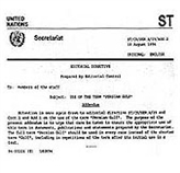
Applications of the Name PERSIAN GULF by International Organizations
Organizations and affiliated foundations have applied the correct name of PERSIAN GULF
since they have been incorporated, excluding one case, which corrected it through Note No.
6
AD311/1GEN dated March 5, 1971. In confirmation and response to the correspondence of
the government of Iran for application of the complete name of PERSIAN GULF in the
publications and deeds of United Nations and affiliated organizations, 14 notes and
correspondences can be mentioned containing the aforementioned note of Secretariat of
United Nations, containing the amendment of Deed IPPD14/UNIDB.
From among the other instructions of United Nations, the following samples can be named:
· Note No. LA45.82 dated Aug. 10, 1984 (New York)
· Circular No. CAB/1/87/63 dated 16.02.1987 of Managing Director of UNESCO.
· ST/CSSER/29 dated Jan. 10, 1990.
· AD/311/1/GEN dated March 5, 1991.
· ST/CS/SER.A/29/Add.1 dated Jan. 24, 1992.
· ST/CS/SER.A/29/Add.2 dated Aug. 18, 1994.
· ST/CS/SER.A/29/Rev.1 dated May 14, 1999.
In all the abovementioned notes and circulars, it has been requested that the water body
existing at the south side of Iran be stated: PERSIAN GULF. The Specialized Group for
Experts on Standardization of Geographical Names, active in the United Nations Social
Economical Council also emphasizes the correct use of historical names for features, and is
active in dispute settlement related to geographical names. "Naphtali Cadman" the head of
Work Group for Toponymy Information has state d that the motivation to change the name of
PERSIAN GULF is purely political.
Background for Application of Incorrect Words Instead ofPERSIAN GULF
After England's attack on Khark Island in 1837, the government of Iran at that time protested
to England's separatist policy in the PERSIAN GULF and officially warned the government
of Britain to avoid mischief intended at separating the southern side of Iran. This warning
caused the Times Journal, published in London in 1840, to name the PERSIAN GULF for the
first time as Britain Sea, but such a name never found any place.
Moreover, following nationalization of the oil industry in Iran in 1950 and dispossession of
English Companies and discontinuation of relations between Iran and England, the Ministry
of English Colonies, for the first time used the incorrect name of this water body.
In these years, the States South of the Persian Gulf were either colonies of Britain or under its
support. To compensate its defeat, the government of England published a book by Roderick
Oven, an agent of English Spy Org., in 1957 which was immediately translated into Arabic.
In this book the assassination of the name PERSIAN GULF began and in 1966, Sir Charles
M. Belgrieve, the political agent of England in the affairs of Persian Gulf Southern States
supported by England, published a book at the end of his mission named: Golden Bulbs at
Arabic Gulf.
After coup of Abdolkarim Ghasem in 1958 in Iraq and then coup by Baas and their claims for
some lands against Iran, they avoided using the name of PERSIAN GULF for political
reasons.
7
In 1960, after Iran and Egypt's disconnection of relationships and after the Arab-Israeli war,
anti Iranian actions culminated due to the previous Iranian regime’s support of Israel. This
occurred in Arabic Circles and in a congress of Baas Party convened at Damascus, in which
participating heads demanded for change of the name of PERSIAN GULF to the forged name
of Arabic gulf, without relying on any legal and historical document. Following this, to
achieve the political motive, they altered this historical name in the text books of Arabic
Countries.
After the Islamic Revolution in 1987, followed by breaking relations between USA and Iran,
and commencement of the imposed war of Iraq against Iran, there have been some efforts to
apply incorrect words instead of the Name Persian Gulf. Most of these efforts were not on
purpose but resulted from unawareness of facts. Though, in USA the geographic and
publication institutes have been hardly influenced by other countries, but in 2005, we
witnessed that the reputable National Geographic Society, with a past history of not accepting
and using forged words in its works, distorted the name of PERSIAN GULF and Iranian
islands and intentionally mentioned incorrect inf ormation. This action only helped damaging
its own international credibility, but ultimately, it surrendered to protests of Iranians
throughout the world and corrected its error.
It is interesting that Mr. Roderick Oven stipulated in Golden Bulbs at Arabic Gulf:
"I visited all parts of PERSIAN GULF and believed that it was Persian Gulf, because I
noticed no map or deed, unless it had named the place as Persian Gulf, but when I watched it
closely, I found out that the people residing at the southern beaches are Arabs, therefore, to be
polite, we should name it: Arabic Gulf."
Either Mr. Roderick Oven should have noticed that on the northern sector of that water body,
up to 1269 km of coast exists with a far larger population who speak Farsi. This is larger than
the Arabian population he was concerned about. He did not notice the important fact that this
sea was first named by the Greeks and neither Iranian nor Arabs took any part in it. The
Muslims and Arab Geographers learned the names from the Greeks and Romans, and used it
in their works, especially that they named Pars Sea, unanimously: Persian Gulf.
In the end, it is worth mentioning that the name of Persian Gulf has been admitted in all the
live languages of the world so far and all the countries throughout the world, name this
Iranian Sea, just in the language of the people: PERSIAN GULF. Even our Arab brothers do
not need to alter a historical name to have a gulf of their own, because there had been a gulf in
their own name previously mentioned in the historical and geographical works and drawings,
which is called at present the Red Sea (Bahr Ahmar).