


Persian Gulf: A Name for All Seasons
Date: 3/9/2014 11:15:02 AM
Persian Gulf: A Name for All Seasons
Mohammad Gharaguzlu Translated by Roya Monajem
Note:
This article is substantially based on a book by by Pirouz Mojtahed-Zadeh, Nam-e Khalij-e Fars dar Derazay-e Tarikh (The Name of the Persian Gulf throughout the History), Sayeroshan Publication, Tehran, December 2004. The original version of the book was Joghraphyay-e Tarikhiy-e Khalij-e Fars (Historical Geography of the Persian Gulf), Tehran University Publication, Series No. 1492, Tehran 1975.
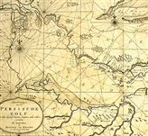
Persian Gulf and Arab Gulf, two distinct names in Ptolemys Map
The famous Greek mathematician and astronomer of 2nd Century BC, Claudius Ptolemy was a great geographer as well. His world map is in the shape of a vast hemisphere showing at least 8000 places. In this map, the Persian Gulf recorded as Sinus persicus is clearly shown. Parallel to it, toward south, we find the name Sinus Arabicus or Arab Gulf. From this important map, which together with its marking method - attracted the attention of Islamic scholars a more important point can be derived: Persian and Arab Gulfs were two distinct seas whose names and limits were known even before Christ.
Persian Gulf in a few Islamic Geographical Maps
Estakharis Masaalek va Mamaalek (Credos and Countries):This book contains maps accompanied with useful commentaries and descriptions. In Estakhris world maps, the earth is shown as a vast sphere surrounded by water. The Caspian Sea is shown surrounded by land, while the Persian Gulf is connected to a peripheral ocean. The interesting point here is like all ancient geographers, Estakhri thought Kaaba was the navel of the earth.
The Map of Persian (Fars) Sea in Ibn Hughals Sourat-ol-Arz (The face of the earth): Here is no place to consider whether the information provided by Ibn Hughal in Sourat-ol-Arz, is just the second or third hand information and duplication of the works of Estakhri and other scholars or not. What is important is that this Arab traveler has clearly talked about Persian Gulf and has dedicated a chapter of the above book to the Persian Sea in which contrary to the present fabrications explains the reason for calling this Gulf as Persian Gulf. Ibn Hughal writes: As I have repeatedly said, the Persian Sea is a gulf of the peripheral sea near China and the city of Waaq continued to Sand, Kerman and Fars and is known as Persian (Fars) among people of all countries. The reason is that Persia is more prosperous than all these countries and its kings enjoyed greater power in the past. At present they rule over the far and near shores of this sea. Ships of all other cities that travel in the Persian Sea and leave the boundaries of their cities, but return to them safe and sound belong to Persia.
In the map of the Arabic text of Sourat-ol-Arz, as in those of all ancient Islamic texts, north is shown below and south above. In Ibn Hughals map, Persian Sea is distinctly shown along Fars and Kerman and is connected to the peripheral sea. In this map, Khuzestan and the three islands, Khark, Laft and Oral situated in the Persian Sea are also clearly marked. Sourat-ol-Arz was written in 978 AD and contains many interesting points in the part dealing with the Persian Sea. For example, in locating the position of the Gholzam Sea, the author writes: A part of the Persian Sea embracing Gholzam up to the shores of Yemen is called the Gholzam Sea. Its length is 30 manzel and its width in its widest part is 3 nights and it then gradually becomes narrower to the extent that the other side of sea is seen from certain places. It finally reaches Gholzam. In his description about the Persian Sea, Ibn Hughal mentions Aden Sea, Omans Alzanj Sea and Black Sea and consider them all as parts of the Persian Sea.
There is a pearl mine near Aden and whatever is extracted from this mine is taken to Aden. If you pass Oman and leave the Islamic domains, you reach Serendip (present Ceylon), waters of that area too is also called Persian Sea. It is quite a wide area with the city of Zanj situated on its shore. On the shores of this sea, there are many lands and terrifying passage ways very difficult to cross, with the most grueling one situated in Jenaabeh (Ganaveh) and Basra. It is called Hur Jenaabeh and is extremely fearful and no ship can cross this place safe when the sea is rough. There is a place in it called Khashaab, which is 6 miles from Abadan toward the Tigris River. Sometimes the sea is so shallow that big ships fear to pass it.
In another place, while describing the geographical position of Persia, Ibn Hughal writes: Among its seas, the biggest is the Persian Sea, as the Basra Sea is called the Persian Sea up to its furthest shore in India.
The map of the Persian Sea in Moajem-al-baldaan: Shahab-al-din Abi Abdollah Yaqut ibn Abdollah al-Hamumi al-Rumi al-Baghdadi is the author of one of the most famous and comprehensive encyclopedias of geography. In the first part of Al-Baldaan, Yaquti provides a simple map of the earth and its important seas. In this map too, a peripheral sea surrounds the earth and Persian and Gholzam Seas are shown as two parallel branches of the huge Indian Sea, while Khaarazm and Jorjan Seas are shown like lakes. In this simple map, the Nile River is also clearly marked.
The map of the Persian Gulf in Aasaar-ol-balaad va Akhbaar-ol-ballad - by Zakaria ibn Mohmmad ibn Mahmud Al-Qazvini, one of the prominent historians and geographers of 13th century and the author of two important books, Ajaaeb-ol-makhlughat va Gharaeb-ol-Mojudaat (Strange Creature) and Aasaar-ol-balaad va Akhbaar-ol-ballad. In Qazvinis map presented in Aasaar-ol-balaad, the seven regions of the world are shown and although it contains new points, but in his conception of the world, this great geographer too was under the influence of his predecessors. A glance at the maps of the world from ancient times to Zakaria Qazvini does not show any major deep change. In Qazvinis map, north is still shown below and south on top, west is on the right side and east on the left. Persian lands including Makran, Kerman and Shiraz are placed among the lands of the third region and the Persian Gulf is clearly marked under the same name. On the right side of the Persian Gulf (toward west) the Barbari Gulf is seen on north of Ethiopia. The same is seen in the book Al-Aalam (the world). Zakaria Qazvini had crossed the Persian Gulf and visited many of its islands, including Kish and described his trips in the above work.
Except these five old maps, there are many maps in reliable geographical texts that clearly speak of the sea on the south of Persia as the Persian Gulf or Sea.
Arabic Maps
1- The Map of the encyclopedia of Al-mosueh al-arabieh al-masireh - The Map of Encyclopedia of Almousouah Al-Arabieh Al-masireh is a comprehensive work of about 2000 pages published by the Franklin Publishing House in Cairo. It is prepared by 120 specialists teaching in various Egyptian Universities under the supervision of Mohammad Shafiq Gharbal. The title of the map is "The Arab State at the peak of its vastness." The interesting point here is that the name of Persian Gulf is written in Persian and it is repeated twice in the text on Persia (Iran). It should be reminded here that the title Arab State is in fact a reference to Islamic conquest that led to occupation of vast areas from east of Persian to Africa and parts of Europe and Spain. Therefore, it was more appropriate to use the term Islamic State.
2- Two very important Iraqi documents: these documents were published during Iran-Iraq war in an Iraqi magazine called Afagh. Both maps show the region now called Middle East from 7th to 11th century. The most interesting point here is that the Iraqi author of the article in which the above maps were presented to document his discussion, uses the old name of Persian Sea. It is interesting because Iraqi people have always been the most serious advocates of calling this sea as Arabian Sea.
3- An official Iraqi document: This important official document is a map called "The Map of Old Places in Iraq," published in 1929 in English together with some guidelines for visitors. The title of the above document and the map were copied from the original. In this map the name Persian Gulf is repeated three times. Remembering the official aspect of this map, showing the region from some millennia before Christ, little doubt remains about the authenticity of the name in question. Another important aspect of this document is the border line between Persia and Iraq which is clearly marked on the west side of the Arvand Rud River, thus showing the Persian sovereignty over the whole length of this river.